The Paddle
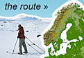
The paddling portion of the journey starts at Jacobs Elv on the border with Russia near Kirkenes high up in the Arctic. The route then follows the exposed Barents Sea coastline for 300 km up to the very north of Norway, namely Nordkinn and rounds it.
 From Nordkinn the journey now follows the Atlantic coastline of Norway for some 2700 km down to Lindesnes again. This spectacular coastline is a mix of exposed headlands and sheltered waters protected by ranks of skerries and islands. It will take me past the spectacular Lofoten Islands and down the kayaking paradise of the Helgeland coast between Narvik and Trondheim.
 From Lindesnes will head north east up Norway’s ‘sunshine coast’ with the wind at my back and the sun on my face for the final 400 km to Oslo where the Scandinavian Odyssey ends. During much of this section I will be protected by ranks of skerries and rocky islands. The whole journey should take about 100 days. The few people who have paddled this coastline before do it in about 80 days.
 The Fjords in Norway are obviously caused but the vast rivers of ice which flowed from the ice cap which covered Scandinavia much in the same way Greenland is covered today. These rivers of ice carved deep valleys which eventually became flooded when the ice withdrew.
The skerries were formed by the same ice sheet. Most of the present skerries were initially submerged when the ice disappeared some 10000 years ago. However, this geological terrane once unburdened with sheets of ice kilometres thick started to rise up again like a cork in thick treacle. As it rose the skerries appeared. Indeed the first camps left by the early settlers some 300 generations ago were located at a previous shoreline. These excavated camps and shell middens are now hundreds of metres above the present shoreline.
It is these same skerries which present some of the greatest hazards. They can lie beneath the water for many waves barely affecting them. When the big sets stealthily arrive the submerged skerries can cause the swell to suddenly pitch into a violent crashing wave.
 The other hazards are tidal races especially where these are flowing in opposite directions to the wind. Some of these tidal races are world famous, none more so than the infamous Maelstrom south of Lofoten. Another is Saltstraumen where the tidal stream can reach up to 40kmph. Luckily these will not be enroute. However there will be others
 Much of the coast may be benign in the summer especially if there is an easterly wind holding the Atlantic swell at bay. But there are also many exposed headlands none more so than the notorious Stadlandet, where even ships sometimes have to wait for the weather. Nordkinn, the meeting place of the Barents Sea and Atlantic Ocean is another notorious headland not to be trifled with.
 During the summer months however Norway is often blessed with longish stable periods of good weather. This coupled with the near continual daylight will mean that when the weather is good I can make eat up considerable chunks of coastline. Then I can recoup when things get windy again.
On the kayaking section I can take a few luxuries I could not carry on the skiing section. The boat I will be using is a Tiderace Xplore X. It has a large capacity. This is however slightly at the expense of its hydrodynamics. While it has a sleek 5.5 metres length, it has a chubby 60 cm width.
 The boat will be specially equipped with both a rudder and a skeg. If the former is damaged the skeg can be deployed. In addition the boat will have extra internal and external keel strips to enable to be man-handled over seaweed strewn boulder beaches.
The large capacity will enable me carry a larger tent, an extra change of clothes and up to three weeks of food and an emergency locator beacon in case I cannot roll nor do a wet entry. In addition, I will also have to carry up to 20 litres of water. I cannot load the boat too heavily as it will need manhandled regularly, and the lighter it is the faster it will be.
I will be camping for much of the kayaking section. Sandy beaches are few and far between with the best being in the very south west and the Lofoten Islands. Most of the coastline is either rock or beaches strewn with cobbles or boulders. But there are usually many good camping spots along the coast above these boulder beaches.
If I complete this round trip with the skiing and paddling sections the total distance covered will be about 6000 in about 7 months