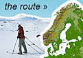
Route Map
The map below shows my progress, if you want to know my last know position check the SPOT map which updates directly from my GPS. My intended route and time frame is described at the bottom of this page below the maps.
![]() Skiing: 1st January – 29th April
Skiing: 1st January – 29th April
![]() Cycling: 30th April – 14th May
Cycling: 30th April – 14th May
![]() Kayak: 15th May – Ongoing
Kayak: 15th May – Ongoing
Current Location – Detail
Route Map
Intended Route
My intended route is to start skiing from Lindesnes in the very south of the Norwegian mainland and then ski all the 2700km to Kinnarodden which is the very north of the Norwegian mainland. This ski trip has been done some 50 times before on skis and is known as “Norge Paa Langs” which roughly translates as “The length of Norway”. It is a skiing journey classic of the highest calibre.
Once I have completed this ski trip up I want to come back down with a sea kayaking classic which is “Norges Kyst” or “The Norwegian Coast”. This challenging kayak journey is about 3000 km in all from the Russian border in the north to the south and then up to Oslo. This kayak journey has maybe been done about 15 times before. I will go round outside all the mainland peninsulas but will go inside many islands. The only island I feel duty bound to go round is Mageroy because Nordkapp, the most northerly point of Europe lies on it and I should go round it. I will head up to Oslo and finish my Scandinavian Odyssey there in the very late summer.
I do not want to use any form of motor during these two classic journeys, not even to resupply. The only engine is myself. I want to combine these two journeys together with a bicycle ride across the north of Norway from Kinnarodden to the Russian border. The 400 km bicycle ride is a means of combining the classic journeys without a motor rather than a classic. I dint think anybody has combined these two classic journeys into a “ski up paddle down” unbroken journey before.